
January 2, 2026, 2:24 pm | Read time: 3 minutes
Imagine if Greenland bordered Portugal, Brazil had no coastline, and Tibet suddenly lay by the sea. Sounds unimaginable, but it really was like that once: about 300 million years ago. We show you how the world map and countries looked back then.
Many millions of years ago, the world looked very different. There were no humans, only a few dinosaurs, and our modern continents were still merged into a massive landmass. There was only one large ocean and a “supercontinent”: Pangaea.
Today, it’s hard to imagine what that must have looked like. That’s why Reddit user LikeWolvesDo, whose real name is Massimo Pietrobon, created a map of the supercontinent Pangaea with our current national borders drawn in. Of course, it’s only a hypothetical map that can’t be 100 percent accurate, but the results are still astonishing.
Seeing our modern world on a single large continent makes one think about how such a geographical situation would influence the relationships between individual countries. What would the world order look like if China were located further north than Greenland? And if the U.S. were the direct neighbor of the West and North African states?
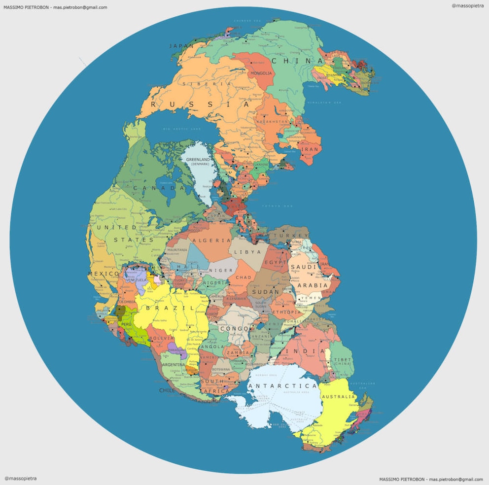
Partly serious and political, but mostly with a lot of humor, the numerous comments that LikeWolvesDo received for his geographical “what if” are worth reading. Reddit users commented on the ancient world map, which shows the arrangement of countries millions of years ago, naturally from the perspective of their respective home countries.
Also interesting: The 44 Most Beautiful Beaches in the World
When Germany Was Still Near the Equator
For example, a French user writes: “See, we really are the center of the world.” In fact, France was much more central in Pangaea than it is today in modern Western Europe. An Australian user, on the other hand, wrote somewhat frustrated: “I was hoping Australia wouldn’t be at the end of the world, but it turns out we were even then the butt of the world.”
A U.S. user writes: “Get away from us, Cuba!” because the island was part of the American mainland on Pangaea.
Also interesting: HERE’s Where You’d End Up if You Dug a Tunnel Straight Down
And a European user commented longingly: “With the crappy weather we have, I really wish Europe were still so close to the equator. Good times.” Because indeed, the European continent was directly on the equator in Pangaea. Germany was quite a sunny place back then.